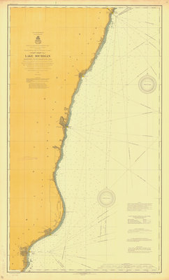
Lake Michigan Coastal Chart No. 1 (Manitowoc to Sturgeon Bay Canal)
Description
- Creator
- Marine Corps of Engineers, Surveyor
- Media Type
- Image
- Item Type
- Charts
- Description
- Coast Chart No. 1
Lake Michigan
Manitowoc to Sturgeon Bay Canal - Date
- 1907
- Map Scale:
- 1:80,000
- Subject(s)
- Corporate Name(s)
- value: Marine+Corps+of+Engineers
Marine Corps of Engineers - Language
- English
- Geographic Coverage
-
-
Wisconsin, United States
Latitude: 44.09194 Longitude: -87.64731
-
- Creative Commons licence
 [more details]
- Copyright Statement
- or something profound
- Copyright Date
- 1907
- Contact us:


